The City of Hamilton is situated in one of Canada’s most vibrant and rapidly diversifying urban landscapes, renowned for its waterfalls and views of the Niagara Escarpment. This unique geography offers a natural playground for anyone looking to get outdoors. Hamilton provides a rich variety of cycling, hiking, horseback riding, boating opportunities, and many more ways to become involved in the active Hamilton community.
Hamilton Geology
Stemming from the steep ridges of the Niagara Escarpment, Hamilton’s landscape is home to various geological gems to be discovered. Found in this guide is information concerning three of the Hamilton communities’ major geological features to keep an eye out for when enjoying the great outdoors. Such areas include the Niagara Escarpment, Hamilton’s many natural waterfalls, and karst features.
The Niagara Escarpment
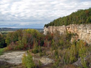 Hamilton is known for its various geological formations, the most evident being the Niagara Escarpment. Locally, this rocky ridge is known as the Hamilton Mountain: a vast region of elevated land in Hamilton that cuts through the city and surrounds the neighbouring Stoney Creek and Dundas Valley. The escarpment contains some of the best exposures of rocks and fossils that date back 400-500 million years and is classified by the United Nations Educational, Scientific and Cultural Organization (UNESCO) as a World Biosphere Reserve. Such designation recognizes the Escarpment as an internationally significant landform valued as both a representative and scientific example of a sustainable relationship between humans and complex ecosystems. The Niagara Escarpment holds significance as one of only 18 biosphere reserves recognized in Canada. On a large scale, the portion of the Niagara Escarpment that runs through Canada is 725km long and runs from the tip of Tobermory over to Niagara Falls. Where the Escarpment extends North of Tobermory to Manitoulin Island, it disappears into Lake Huron and eventually reappears in Wisconsin.
Pictured: View of the Niagara Escarpment, Hamilton, ON
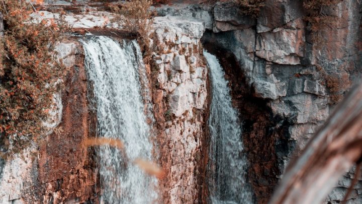
Waterfalls
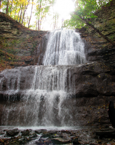 Hamilton is home to over 100 waterfalls and cascades along the Niagara Escarpment! The Escarpment provides a rocky environment comprising plummeting cliffs and dramatic elevation changes, creating a perfect geological environment for waterfalls. Being the Waterfall Capital of the World, there used to be more waterfalls flowing in Hamilton than exist today. However, many were damaged or have slowly vanished as roadways were built and industry moved into the area, paving over natural wetlands and harming the city’s natural drainage and the ecology of Hamilton Harbour.
The waterfalls are distinctly unique land formations that differ in size and flow. Waterfall accessibility also varies; where one waterfall requires minimal walking on well-groomed trails, another may need an experienced hiker who is willing to trek a long distance for a perfect view (Be sure to check out the Resource Guide on Trail Accessibility for more information concerning unique accommodation trail features). On a cautionary note, since the Hamilton waterfalls are often along steep drops with loose, rocky debris, slipping hazards are significantly increased. For this reason, it is essential to stick to marked paths and viewing areas when exploring any waterfall in the area.
Pictured: Sherman Falls, Hamilton, ON
Karst Features
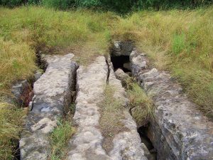 Hamilton is home to the most extensive cave system in Ontario, Eramosa Karst, a geological land formation with caves, drainage basins, underground rivers and much more! A Karst is a landscape formed by dissolved water-soluble rocks such as limestone, dolomite, and gypsum. The geological formation of a Karst occurs over thousands of years. It involves a process called ‘Carbon-Dioxide Cascade’ where carbon-dioxide-rich rainwater falls and collects in the soil. Over time, as the amount of carbon dioxide builds in the soil, it forms a weak carbonic acid solution that will begin to dissolve and erode at the surrounding rock. Eventually, these cracks and crevices with grow into drainage systems, caves, sinkholes, and other identifiable Karst features. Visit Geology Ontario, or any other links found in the sidebar, for more information concerning this geological feature and more!
Pictured: Nexus Cave entrance at Eramosa Karst Conservation Area, Hamilton, ON
Hamilton Ecology
The Hamilton Forest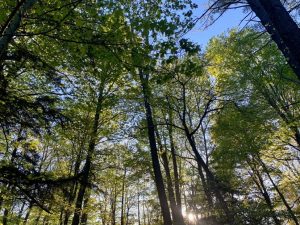
The importance of forests can’t be understated. Much of the world depends on the health and wellness of forests for survival: from the air we breathe to the food we eat and the houses we build. Beyond what we can see, forests offer watershed protection, prevent soil erosion and even combat climate change. Forests are crucial ecosystems deserving of respect for their importance. Hamilton is home to a number of forests with lots to see, discover and admire. Included here is more information about Hamilton’s forests and fun facts about forests to keep an eye out for throughout the year.
Pictured: McMaster Forest, Hamilton ON
The Carolinian Forest
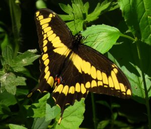
The forest ecosystem found in Hamilton is a small section of the Carolinian forest, an ecozone that extends from North and South Carolina in the United States to Southern Ontario. This unique ecosystem occurs nowhere else in Canada and, although making up 1% of Canadian forests, contains a greater variety of plants and animals than any other ecosystem in the country. This dense forest region results from a temperate regional climate unique to this region of Canada. It allows for the flourishing of flora and fauna typically found in the Southeastern United States. Such species include Sassafras, Hackberry, Sycamore, Spotted Salamander, Virginia Opossum, Baltimore Oriole, and Giant Swallowtail Butterfly.
Pictured: Giant Swallowtail Butterfly (Papilio cresphontes)
Fun Forest Facts
Why Leaves are Green – Leaves are green because they contain the pigment chlorophyll. Chlorophyll is responsible for photosynthesis, the process by which a plant’s leaves combine water and carbon dioxide with energy from the sun to make food. Without photosynthesis and the fresh air leaves produced, life on earth could not exist.
Why Leaves Change Colour in the Fall –  With Autumn comes the change of the Summer green foliage of deciduous trees into a mix of red, purple, orange and yellow, resulting from a chemical process within the tree as winter approaches. During the Spring and Summer months, the leaves serve as factories where food and nutrients necessary for tree growth are produced from chlorophyll. This chemical gives leaves their green pigment and absorbs energy from sunlight to transform carbon dioxide and water in carbohydrates. Also contained in the leaves of a tree are yellow and orange pigments (from the chemicals carotenes and xanthophyll) that are masked and overwhelmed by the abundance of green chlorophyll. However, in the fall, leaves stop their food-making process because of a change in temperature and a decrease in daylight hours. Therefore, as the chlorophyll breaks down, other colours replace the typically green hue. As the fall colours appear in the forest canopy, other changes are also occurring! For instance, at the point where the stem of the leaf meets the branch, a build-up of cells develops and eventually breaks the tissues attaching the leaf to the tree. The tree simultaneously seals the break so that when the blade finally falls from the tree, it leaves behind a small scar. Most broad-leaved trees in Ontario shed their leaves during the fall. The exception is trees like Oaks, whose dead brown leaves will remain on the tree until Spring growth begins.
Stratification – In deciduous forests like those found in Hamilton, you may notice a pattern of distinct vertical layers of foliage. This layering is called stratification, and is an important part of healthy forests in this region. The top layer is the canopy, formed by the tops of the tallest and oldest trees. Canopy species include oaks, maples, and beeches, among other large trees. Right below this layer is the understory, a layer of smaller tree species and younger canopy-forming species. Understory species include larger dogwood species and sassafras. Next is the shrub layer, composed of smaller shrubby species. Some species in this layer are viburnums, elderberries, and spicebush. Below the shrub layer is the herb layer, made up of small perennial and annual plants such as wildflowers and ferns. Spring ephemerals are also part of the herb layer. Finally, the last (but definitely not least) layer is the litter layer, the term for the decomposing leaves and wood on the forest floor. This layering may be more or less pronounced depending on the health and biodiversity of the forest. Stratification also explains the order in which plants leaf out during Spring. The plants growing in the herb layer are covered in nearly full shade during peak growing season, so they often leaf out first to gather as much early Spring sunlight as possible. Next, the shrub layer leafs out for the same reason; taking advantage of what sunlight it can get before it gets shaded out. Finally, the remaining layers leaf out as the season progresses. This process allows a wide diversity of plant species to all survive in the same location and get the resources they need, adding complexity to the forest ecosystem.