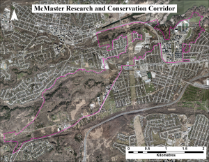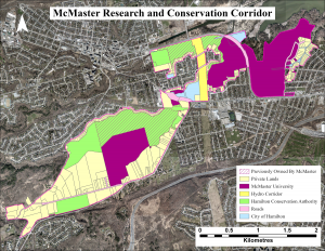
The McMaster Research and Conservation Corridor is an ecological link between the Dundas Valley and Cootes Paradise, measuring approximately 1180 acres. Starting from the area around Sherman Falls and continuing all the way until Cootes Drive and McMaster University. The conservation corridor eco-link gets its name from McMaster University’s connection to the land within the corridors borders. Almost half the land, 556 acres (47.1%), found within the ecological corridor is either currently owned by McMaster University or was previously owned by McMaster. Currently, 668 acres (56.6%) of the land within the ecological corridor is protected in some way; through ownership by McMaster University 375 acres (31.8%) or the Hamilton Conservation Authority 293 acres (24.8%).
The McMaster Research and Conservation Corridor is made up of both land and creek connections (two major tributaries being, Ancaster Creek and Sulphur Springs Creek), with only 4 ecological barriers being present along the corridor. All four ecological barriers are roads and include Old Ancaster Road, Lower Lions Club Road, Osler Drive, and Cootes Drive. Other negative ecological impacts on the corridor include invasive species, land encroachment and dumping, water quality impairments, and watercourse obstructions to fish movement. There is currently residential development and roads bordering almost the entire perimeter of the corridor, which poses issues to animal migration/movement.
Partners include McMaster University, the Hamilton Conservation Authority, the City of Hamilton, the Hamilton Naturalists’ Club, and private landowners within and adjacent to the corridor.
The Corridor represents the land from Sherman Falls to Cootes Paradise along the Ancaster Creek Valley. The purpose of the project is to conserve this high biodiversity area, maintain and enhance ecological connections, and enhance environmental research opportunities and studies on a wide range of topics.
The ecological corridor is part of the Spencer Creek Watershed: Ancaster Creek Subwatershed: Lower Valley and Lower Ancaster Creek Catchment Areas.